Iowa Weather: Heavy Rain Sunday, Severe Storm Risk Monday
Iowa is transitioning into an active weather pattern featuring widespread rain on Sunday, a conditional severe storm risk on Monday, and potential flash flooding.
- Core Development: Iowa is transitioning into an active weather pattern featuring widespread rain on Sunday, a conditional severe storm risk on Monday, and potential flash flooding.
- Beat Context: Categorized under Transport with independent corroboration.
- Reporting Depth: 4 minute analytical read synthesized from verified newsroom sources.
Iowa is heading into a significantly wetter and more active weather pattern, transitioning from post-frontal cool conditions into widespread rain on Sunday followed by a conditional severe weather threat on Monday, according to Iowaweather reporting. The shift arrives as a cold front moves through, bringing noticeably cooler and drier air with dew points falling into the 40s and 50s across northern and western parts of the state. While Saturday afternoon remains largely quiet, late-night moisture surging back north will lay the groundwork for multiple rounds of rain, thunderstorms, and potential flooding concerns that could persist through the middle of the week.
The transition marks a sharp contrast across the state, with high temperatures ranging from the lower 70s in northwest Iowa to around 80 or the lower 80s toward the southeast. Atmospheric capping and limited instability are expected to keep Saturday storm development isolated, with any stronger cell remaining largely confined to southern areas near and south of Highway 34, IowaWeather notes. However, conditions change significantly by Sunday as moisture spreads north ahead of developing low pressure over the Plains, bringing high humidity and cooler, fall-like temperatures mostly staying in the 60s and lower 70s.
Media additions



Confidence remains high that rain will become widespread Sunday night, driven by a strengthening low-level jet transporting warm, moisture-rich air across a stationary boundary. Atmospheric moisture values could approach exceptionally high levels for the season, allowing storms to produce heavy rainfall efficiently. Forecasters warn that travel could become hazardous along stretches of Interstate 80, Interstate 29, and other major routes due to ponding water and reduced visibility. This initial soaking sets the stage for a more complicated severe weather setup on Monday.
Monday brings the best opportunity for organized severe weather as a strengthening storm system pulls warmer air northward and increases wind shear across multiple atmospheric levels. According to IowaWeather, damaging straight-line winds and large hail are plausible if storms organize into clusters or a line, though the overall tornado threat remains lower due to limited instability caused by persistent cloud cover and rain. The threat may shift from western Iowa earlier in the day toward central and eastern areas by Monday evening.
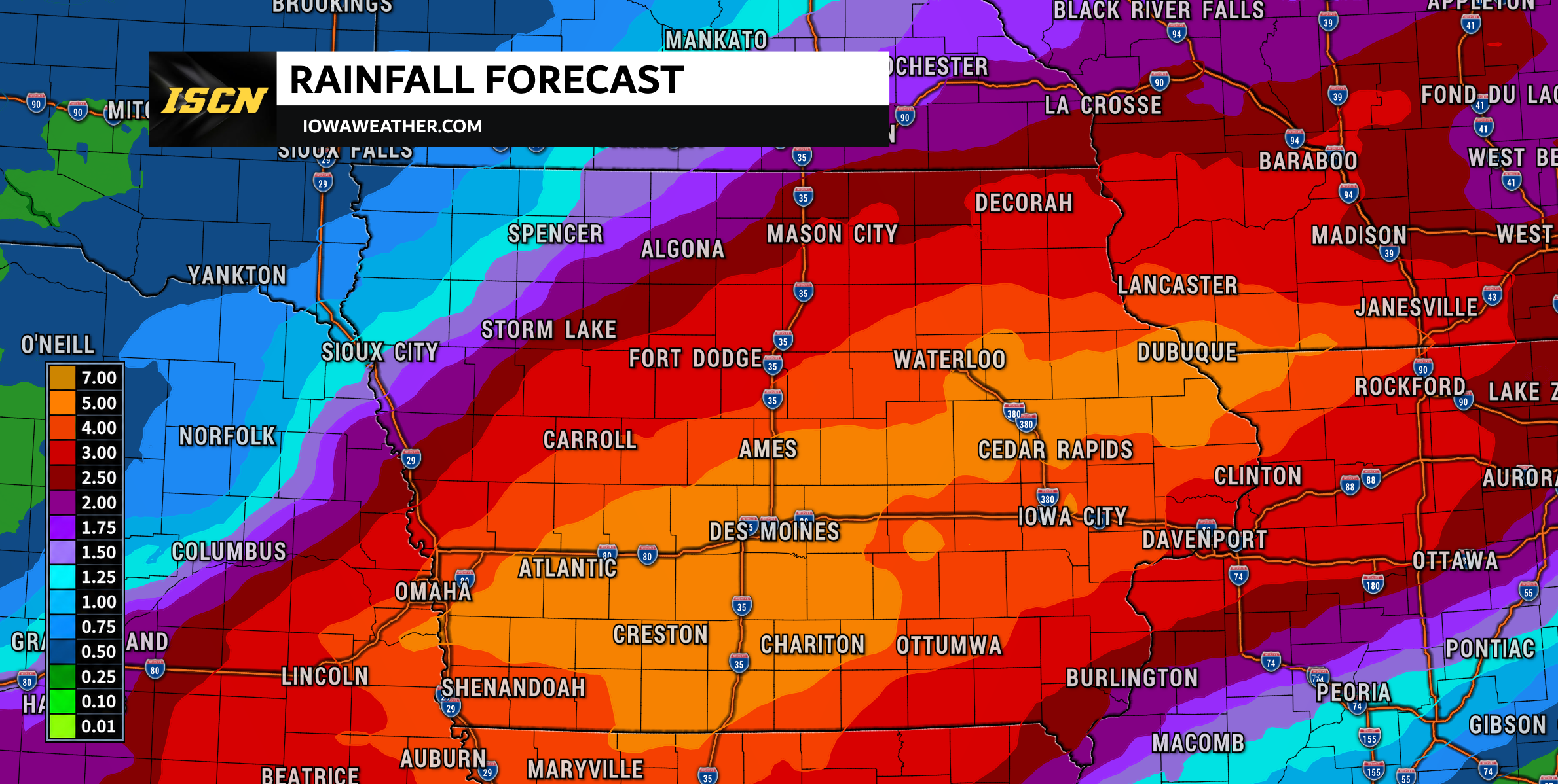
Beyond Monday, attention shifts heavily toward a stationary frontal boundary that could trigger repeated rounds of thunderstorms—a phenomenon known as training—through Tuesday and Wednesday. Multi-day rainfall totals of 3 to 5 inches are possible near the boundary, raising concerns for flash flooding, urban drainage issues, and eventual river flooding. The precise location of these high rainfall bands remains uncertain, as a shift in the front by even 50 miles could alter the distribution.
Broader meteorological shifts are simultaneously affecting other regions. In the Carolinas, Wach reported severe thunderstorm risks driven by high instability and tropical humidity, accompanied by wildfire smoke from Oregon and Washington creating hazy skies. Meanwhile, Texas Storm Chasers outlined an extreme pattern flip from wildfire danger in the Panhandle to heavy rain and flood risks across Texas. Similar active conditions stretch across the Northern Plains, where KOTA Territory News reported severe storm and snow potential, and Wisconsin, where WBAY tracked an impactful spring storm.
| Region / Outlet | Primary Weather Event | Key Hazards |
|---|---|---|
| Iowa (IowaWeather) | Active frontal pattern starting Sunday | Heavy rain, localized flooding, Monday severe storms |
| Carolinas (Wach) | Cold front following extreme heat | Damaging winds, large hail, brief tornado risk |
| South Dakota / Plains (KOTA Territory News) | Pattern shift from dry warmth to severe weather | Large hail, very strong winds, heavy rain and snow |
| Wisconsin (WBAY) | Spring storm system | Freezing rain, ice accumulation, strong storms |
| Texas (Texas Storm Chasers) | Wildfire danger shifting to multi-day flood risk | Extreme fire spread, flash flooding, river flooding |
What to Watch Next
- Monitor live weather radar updates Sunday night as widespread rain expands and moisture transport increases.
- Stay alert to local severe weather bulletins on Monday afternoon and evening for damaging wind warnings.
- Track frontal boundary positioning through Tuesday and Wednesday to assess localized flash flood and river flood potentials.
As the weather pattern evolves, residents across affected areas should maintain flexibility, keep weather alerts enabled, and avoid driving across flooded roadways.
How significant is this development?
Contribute your assessment to the aggregated reader sentiment ledger.
Frequently Asked Questions
Key questions answered in this reportWhat is the key development in: Iowa Weather: Heavy Rain Sunday, Severe Storm Risk Monday?
Iowa is transitioning into an active weather pattern featuring widespread rain on Sunday, a conditional severe storm risk on Monday, and potential flash flooding.
Why is this Transport development significant for the UK?
This report covers critical events in our Transport beat. Independent reporting monitors related UK statements, regulatory shifts, and public responses as further verified details emerge.
How was this reporting corroborated and verified?
Newsarchy UK compiles and cross-references reporting from primary reporting from IowaWeather.com and cross-checked wire reports. All coverage adheres to published editorial standards.
When was this report published?
This briefing was published on September 17, 2026 and is permanently cataloged in the Newsarchy UK Transport archives.