Hurricane Polo intensifies to rare category 5 storm off Mexico coast
Hurricane Polo has rapidly intensified into a rare Category 5 storm off Mexico's Pacific coast, packing 180 mph winds and prompting high alerts for severe flooding.
- Core Development: Hurricane Polo has rapidly intensified into a rare Category 5 storm off Mexico's Pacific coast, packing 180 mph winds and prompting high alerts for severe flooding.
- Beat Context: Categorized under World with independent corroboration.
- Reporting Depth: 3 minute analytical read synthesized from verified newsroom sources.
Hurricane Polo has rapidly intensified into a rare Category 5 storm off the southwestern coast of Mexico, driven by exceptionally warm waters and atmospheric conditions associated with the ongoing El Niño phenomenon, according to reports. The storm's sudden escalation has placed federal and local authorities on high alert for torrential rainfall, life-threatening floods, and dangerous mudslides, even as forecasters project that the system's core will remain offshore.
The system's explosive growth caught weather experts by surprise. According to data from the BBC, a US National Oceanic and Atmospheric Administration (NOAA) Hurricane Hunter aircraft flying into the storm recorded sustained winds near 180 mph, with central surface atmospheric pressures dropping to approximately 892 mb, placing Polo among the most powerful eastern Pacific storms on record.
Media additions


The Miami-based National Hurricane Center (NHC) described the 24-hour intensification period as truly remarkable. Meteorological assessments from Sacbee detailed how Polo's winds surged dramatically within a 22-hour window, marking it as the third Category 5 hurricane of the eastern Pacific season.
| Storm Metric | Reported Figures & Estimates |
|---|---|
| Maximum Sustained Winds | 160 mph to 180 mph (approx. 260 km/h to 285 km/h) |
| Central Surface Pressure | Approximately 892 mb |
| Season Category 5 Count | Third Category 5 hurricane in the eastern Pacific basin this season |
| Forecast Rainfall Totals | 3 to 6 inches, with isolated totals up to 8 inches (approx. 15 cm to 20 cm) |
Unusually warm ocean waters have served as the primary engine for the hurricane. Scientists monitoring the region reported that daily sea surface temperatures in the central-eastern Pacific reached 3.05°C above average, surpassing the previous record set during the 2015 El Niño event, as highlighted by Hindustan Times and Yale Climate Connections. These thermal conditions, amplified by planetary Kelvin waves pushing warm plumes up the Mexican coast, have created a deeply conducive environment for sustained intensity.
Mexican President Claudia Sheinbaum stated that current information indicates Polo will avoid a direct coastal landfall, though she urged residents along the Pacific to remain vigilant. Authorities in states including Jalisco, Colima, Michoacán, and Guerrero have taken precautionary measures.
The storm's atmospheric influence extends far beyond Mexico's immediate coastline. According to News — Hurricane Polo Intensifies to Category 5 as Multiple Storms Form in Pacific, moisture plumes being pushed northward are expected to bring heavy rainfall and flash flood risks to the southwestern United States, including New Mexico.
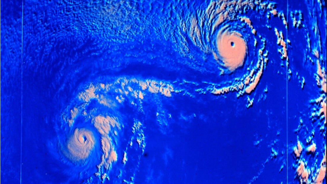
Forecasters are also closely monitoring Tropical Storm Odalys, operating further out in the Pacific. As both systems drift, meteorologists warn that they could engage in the Fujiwhara Effect — a rare meteorological interaction where nearby tropical cyclones orbit a common center, introducing significant unpredictability into the long-term track forecasts.
For ongoing updates on global meteorological events and related regional developments, consult World coverage.
Aircraft operated by the U.S. Air Force Reserve reconnaissance squadron and NOAA are scheduled to fly additional investigative missions into Hurricane Polo over the coming days to gather real-time data. Authorities will continue evaluating steering currents and storm trajectory models as Polo makes its anticipated turn toward the northwest.
How significant is this development?
Contribute your assessment to the aggregated reader sentiment ledger.
Frequently Asked Questions
Key questions answered in this reportWhat is the key development in: Hurricane Polo intensifies to rare category 5 storm off Mexico coast?
Hurricane Polo has rapidly intensified into a rare Category 5 storm off Mexico's Pacific coast, packing 180 mph winds and prompting high alerts for severe flooding.
Why is this World development significant for the UK?
This report covers critical events in our World beat. Independent reporting monitors related UK statements, regulatory shifts, and public responses as further verified details emerge.
How was this reporting corroborated and verified?
Newsarchy UK compiles and cross-references reporting from primary reporting from Latest news from Azerbaijan and cross-checked wire reports. All coverage adheres to published editorial standards.
When was this report published?
This briefing was published on September 23, 2026 and is permanently cataloged in the Newsarchy UK World archives.