Met Office explains how yellow, amber and red weather warnings work
The Met Office categorizes weather warnings based on the impact and likelihood of severe conditions to help the public prepare for safety and travel risks.
After a rare red extreme‑heat warning hit the Midlands and a series of yellow thunderstorm alerts threatened power cuts across 25 areas, the public is asking what the different colour levels actually mean. Understanding the system is now a matter of safety, travel planning and protecting homes from flooding or power loss.
Why the colour code matters now
The Met Office’s National Severe Weather Warning Service (NSWWS) is the backbone of the country’s early‑warning regime. Recent high‑profile warnings have put the system under a brighter spotlight, making it essential that people know how to react at each level.
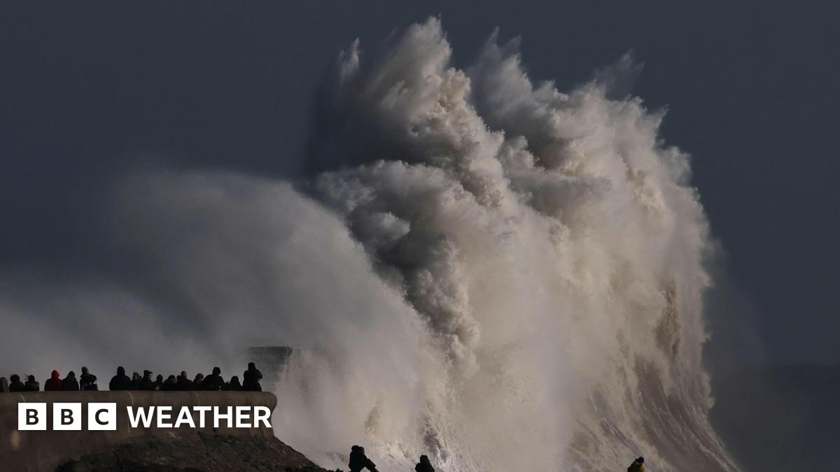
Media additions


The matrix in practice
According to the Bbc’s explainer on weather warnings, the Met Office places a tick in a matrix that matches the impact of the weather against the likelihood of it occurring. A tick in the lower‑impact, lower‑likelihood box triggers a yellow warning; moving the tick up a row or column upgrades the colour to amber, and the top‑right corner produces a red warning. The matrix is not published for the public, but the resulting colour and a map of the affected area are shown on the BBC Weather website and the Met Office app.
The same colour logic is echoed on the GOV.UK guidance page for early warning and weather forecasts. It stresses that warnings are issued when hazardous weather could impact “society across sectors”, and that an interactive five‑day map lets users see whether a warning is in force for their location.
What each colour means
| Colour | Public message | Typical impacts |
|---|---|---|
| Yellow – “Be aware” | Severe weather is possible over the next few days; plan ahead. | Potential travel delays, localized flooding, minor power interruptions. |
| Amber – “Be prepared” | Increased likelihood of severe weather; ready to change plans. | More likely travel disruption, road and rail closures, higher flood risk, possible risk to life or property. |
| Red – “Take action” | Extremely bad weather is expected; act now to stay safe. | Widespread damage, significant travel and power disruption, life‑threatening conditions. |
Yellow warnings in the field
In early September 2025, the Met Office issued a yellow thunderstorm warning for a swathe of southern and central England. The agency’s public statement read:
"A band of heavy rain and thunderstorms will move north across the area giving one to two hours of intense rain before clearing northwards. Some places could receive 30–40mm of rain in this time, along with a risk of frequent lightning and hail."
The warning covered areas from Devon and Dorset up through Somerset, Gloucestershire and into parts of Wales and the West Midlands. The agency warned that the heavy rain could overwhelm drainage, cause flash flooding and trigger power cuts. Local authorities were told to monitor the situation closely, and travellers were advised to expect poor visibility and surface water on roads.
When the same weather pattern struck Scotland on 30 June, the Met Office paired the yellow rain warning with a specific power‑cut advisory. The Express reported that “Some short term loss of power and other services is possible” in 20 Scottish areas, while a separate notice warned of “Some interruption to power supplies and other services possible” in five Northern‑Ireland locations.
Escalating to amber
Amber warnings shift the call to action from “plan ahead” to “prepare now”. The BBC notes that when confidence in the forecast rises, an amber warning “is time to start putting your plans into action as travel disruption is more likely and there is a potential risk to life and property.” Recent examples include amber snow warnings for Storm Goretti in January 2026, which warned of icy roads and limited visibility, and amber heath‑alert upgrades that accompany heat waves, urging people to stay hydrated and avoid strenuous outdoor activity.
Red – the rarest and most severe level
Red warnings are issued only when the Met Office believes “dangerous, potentially life‑threatening weather is expected imminently”. The BBC’s coverage of the June 2026 red extreme‑heat warning explains that the service “is rare, only issued in the most extreme cases”. The warning covered the Midlands, south‑east Wales and southern England, with temperatures forecast up to 40°C. It warned of “substantial disruption to travel, energy supplies and possibly widespread damage to property and infrastructure”.
Such a red warning was only the second ever issued for extreme heat since the scheme began in 2021; the first was in July 2022 when temperatures of 40.3°C were recorded in Coningsby. The Met Office also issued red heat‑health alerts through the UK Health Security Agency, indicating “severe impacts expected across health and social care services”.
Linking weather warnings with health alerts
The Gov guidance distinguishes the weather‑warning system from the “Weather‑Health Alerting System” run jointly by the Met Office and the UK Health Security Agency (UKHSA). While the colour warnings focus on physical impacts such as travel and property damage, the health alerts trigger when temperatures threaten the wellbeing of the population.
How the warnings reach the public
The Met Office uses a “wide variety of media” to disseminate warnings, from TV and radio to online maps and smartphone alerts. The BBC frequently republishes the warning map on its weather centre, and the Met Office’s own website provides a 7‑day forecast that includes the colour status for each region.
Local resilience forums – multi‑agency partnerships that include emergency services, the NHS, the Environment Agency and utilities – receive the warnings directly. They coordinate responses such as road closures, flood‑risk management and power‑grid protections. Category 2 responders like the Highways Agency also share the information with the public.
What to watch next
- Mid‑week: the red extreme‑heat warning is due to expire at 21:00 GMT on Thursday, with the Met Office monitoring for a possible downgrade.
For up‑to‑date maps and detailed advice, readers can visit the BBC Weather website or the Met Office’s own warning page. The same information is mirrored on the GOV.UK early‑warning portal, where the interactive map highlights any active warnings within five days.